
Chapter Relevance
Lab Relevance: ★☆☆ (Relevant idea to writing any spatial data processing script)
Project Relevance: ★☆☆ (Important approach for automating workflows across spatial datasets)
Foundation: ★★★ (A non-negotiable core programming concept)
Time to Read: 4 minutes
In a nutshell: This chapter explains the transition from manual, line-by-line coding to automated, scalable data processing using loops and conditions.
Skip this if: You already understand why loops (for / while) and conditional statements (if / else) are necessary for scaling code beyond a single variable.
So far, you have learned how to store values and collections of values. You can define variables, work with lists, and access individual elements.
However, writing useful spatial programs requires more than just storing data. It requires processing data systematically.
This section explains why automation is necessary before you learn how to implement it.
1. The Limits of Manual Code
Programming becomes powerful when code can scale beyond a single value.
To understand why, let’s ask a new kind of question:
What if the same operation must be applied to many values?
Consider a simple list of major cities:
cities = ["Lagos", "Nairobi", "Dhaka", "São Paulo"]
Suppose you want to display each city. One option is to access each element manually using its index:
print(cities[0])
print(cities[1])
print(cities[2])
print(cities[3])
Lagos
Nairobi
Dhaka
São Paulo
This works, but only as long as the list stays exactly the same.
Why this approach does not scale
Manual repetition quickly becomes a problem. Issues appear when:
the list grows longer (imagine 500 cities!)
the order of cities changes
a city is added or removed
For example, if you add one more city to the data:
cities.append("Kinshasa")
Your code will still only print the first four cities. You would have to manually type print(cities[4]) to fix it. The real issue here is not indexing; the issue is manual repetition.
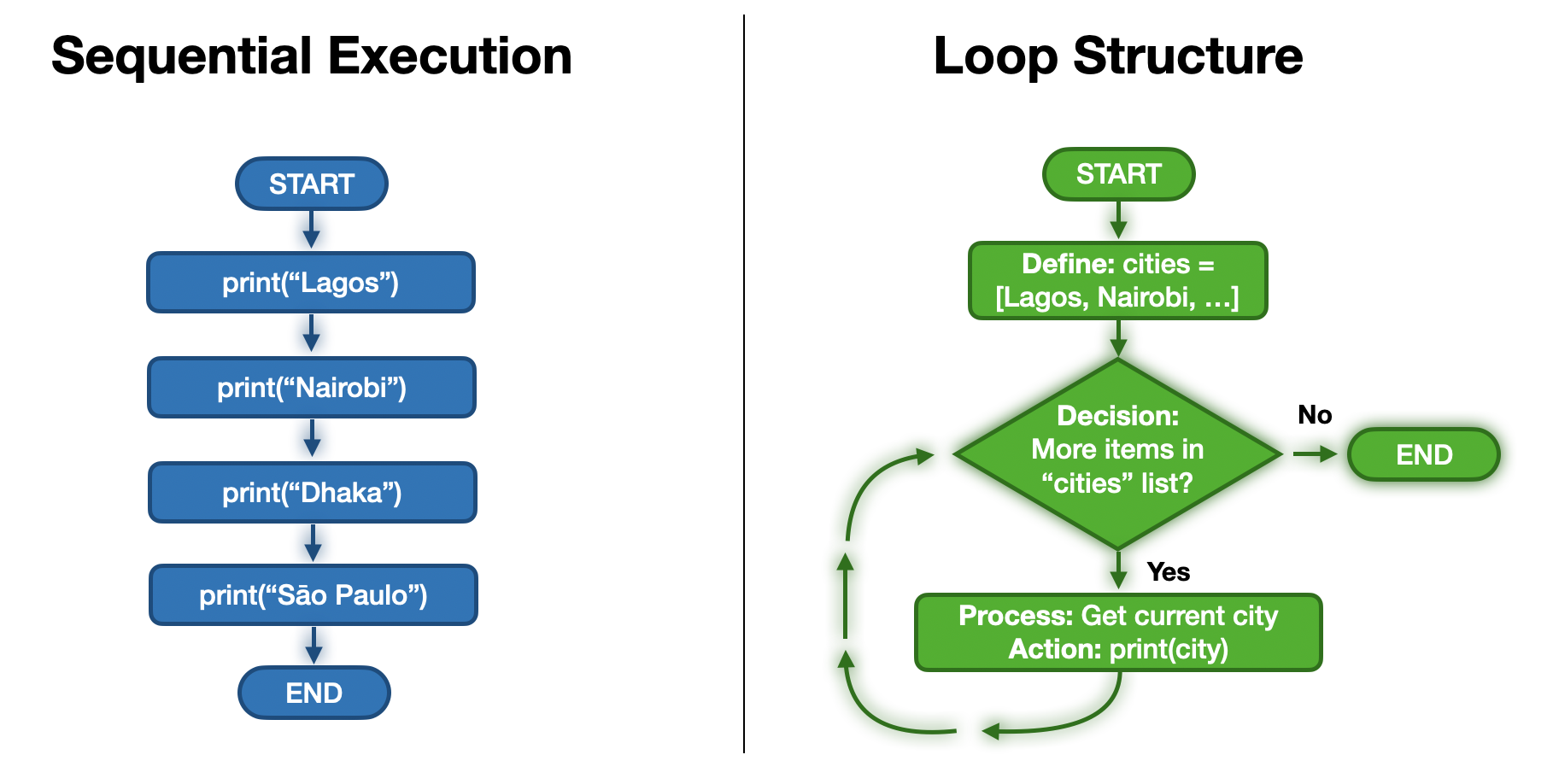
Sequential execution requires writing a new line for every step. A loop reuses the same line of code by cycling through the data until it reaches the end.
2. The Solution: Looping
What we really want to express to the computer is not:
“Print city 0, then print city 1, then print city 2…”
but rather:
“For each city in this collection, print its name.”
This idea is called iteration (or looping). Instead of repeating code yourself, you write the instruction once and let the computer repeat the work for you.
Here is a sneak peek of what that looks like in Python:
for city in cities:
    print(city)
Lagos
Nairobi
Dhaka
São Paulo
Kinshasa
Interactive Explorer: Loop Scalability Visualizer.
Run the simulation to see how manual execution and loop execution produce the same initial result. Then, add a city to the list and run the code again to witness exactly why manual indexing fails when data scales. For improved visibility of the explorer, follow this link.
3. Making Loops Smarter with Decisions
Repetition alone is incredibly useful, but in real-world spatial data science, you rarely want to treat every single value exactly the same way.
Imagine you want to loop through a massive list of cities, but you only want to:
print the city if its population is over 1 million
classify it differently if it is coastal vs. inland
skip the entry entirely if its coordinates are missing
Now the program must not only repeat actions, but also decide what to do for each value. This is where conditions become important.
From Values to Logic
Every decision has the same basic shape:
check a condition
choose what happens next
This introduces another core idea:
Code can branch based on conditions.
This is how programs react to data instead of just processing it blindly.
4. Repetition & Decisions Go Together
In real workflows, repetition and decisions are often combined.
Typical patterns include:
go through many values
decide something about each one
Examples from geospatial and environmental work include:
checking each coordinate for validity
classifying cities by region
filtering measurements based on thresholds
Repetition handles how many times. Decisions handle what to do.
5. Concept Check: The Scaling Problem
You are given a list of river names, and you need to print each one. Currently, there are four rivers: rivers = ["Nile", "Congo", "Zambezi", "Niger"]. You write four separate print() statements using manual indexing (e.g., print(rivers[0])).
Tomorrow, your colleague updates the database, adding 15 new rivers to the list. If you do NOT use a loop, what happens when you run your script?
A) The script automatically detects the new rivers and prints all 19 of them.
B) The script crashes with an IndexError because the list length has changed.
C) The script only prints the first four rivers, completely ignoring the 15 new ones.
Check your understanding
Answer: C
Manual indexing is rigid. Your four print() statements will flawlessly print the first four items, but they have no way of knowing the list has grown. A loop, however, automatically adapts to the size of the data structure, meaning the exact same code would print 4 rivers today and 19 rivers tomorrow.
What Comes Next
Next, we will:
express repetition using
forloopsunderstand how indentation defines what gets repeated inside the loop
see how loop variables change step by step
connect loops to lists, indices, and simple spatial data
Once this mental model of repetition is in place, we will add conditions so your loops can behave dynamically!